Linggo, Pebrero 21, 2016

Chasing waterfalls series : delightful morning at Bukal falls


A spontaneous plan turn out to be a success.

I was delightfully surprised with a short visit to Bukal Falls. The serenity and the spectacular view is definitely worth the hike to get to the falls. Yes, there was a short hike - but it was all worth it. It is absolutely serene and the place was fantastic.  I was so amazed when I reached the waterfall. It was so beautiful. It was also quite an adventure to swim in the very cold, clear, blue-green,deep, and calm waters amidst nature. I couldn't resist jumping in because it was just too tempting. I will say that the water was shockingly cold but I'm glad I jumped in. I will definitely be back - and maybe stay a little longer.

Bukal Falls is beautiful and If you love nature this is the place that you can reconnect with yourself. But be sure to visit it on a weekday so you can enjoy your spot at the falls.

To get there, there is a bus from LRT/Buendia or Cubao to Santa Cruz, Laguna.Once you reach Sta cruz, you can either ride a jeep bound to Majayjay and get off at Barangay Bukal or you can directly hire a tricycle and tell the driver you are headed to Barangay Bukal.

I look forward to coming here again next time. 


Linggo, Pebrero 7, 2016

Gorgeous walk at Mt. Ulap and Hydro Falls


MT. ULAP ECO-TRAIL
Itogon, Benguet

Entry point: Brgy. Ampucao, Itogon
Exit point: Brgy. Sta. Fe, Itogon
LLA: 16.2904 N, 120.6312 E, 1846 MASL (Mt. Ulap)
Days required / Hours to summit: 1 day / 2-3 hours
Specs: Difficulty 3/9, Trail class 1-3,
Features: Grassland and pine ridges, scenic views of the Cordilleras, burial caves


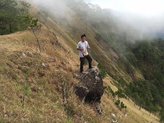
I love the pictures I have seen from people standing on the edge of a protruding rock that looked like it will break at any moment. Upon my research, I found out that the rock formation is part of the features of Mt Ulap eco-trail. I figured I had to go check it out for myself.  I had wanted to do this hike for awhile, but just never had the opportunity until recently.

7 AM

We started the hike a little later than we anticipated , got there just before 6 am. After the registration and a quick orientation the group started right away. 

The morning air was a little cooler when we started, but as the hike continued, we were definitely sweating.  It is straight uphill from the beginning - On the hike up, you could see beautiful views of the surrounding mountains, and the scenery is gorgeous right from the start to finish.

The beginning is a bit challenging- it's a little steep- but once you get to the start of the trail going to the first peak , it is easy with a little danger but with a shaded trail. 

This is a fun hike. It is moderately easy climb but with a longer trail than I expected.   Our group went at a moderate pace with some breaks. 

When we finally reached the Gungal Rock, there was a long line of people wanting to take pictures on the rock. It was a Sunday noon, so I'm sure there would be less people on a weekday. I can see why people would want to give this place a bad review due to the long line but in terms of the actual hike, it was very enjoyable and had great views almost the entire way up and down , so I would say it was worth the hike.

As we were making our way down the mountain, the trail was noticeably more crowded. Plus, it was steeper.  Coming down may have been slightly faster than hiking up the mountain, but it's also scarier because the path gets slippery, just be extra careful from the rocks and some roots jutting out. 

Here are some tips for some of you who plans to hike Ulap. 


Go early. Our group planned to start early on a Sunday. We didn't end up starting until around 7 a.m. So before it gets hot and before the trail gets more crowded start the hike early. Or i suggest Go on a weekday to avoid long lines of people.

Bring enough water and pack light. The sta fe traverse is longer than expected. From the first peak going to Gungal rock it is mostly expose to the sun. 

Take alot of pictures - we had fun with this experience and took photos. 


Sabado, Enero 30, 2016

Reuniting with Mt. Tarak


The last time I did Tarak is back in 2011, back then it is in my head as one of my favorite hike. And, on my 3rd visit to Mt. Tarak, I reunited with my hiker cousins, Rodnie and Reynald.

We began the hike around 3:00 pm - and the sun is still out. The weather is pretty good, and the trail itself is well shaded.  It starts out slow and kind of flat before you get to the actual base of the mountain which starts from Nanay Cording's house, and from there it gets steeper.

The advantage of hiking late in the afternoon was the temperature. It was still relatively warm at 4:30-5, but not unbearably hot. In total, it took us 4 hours to hike up to the summit. 

The trail is not a peaceful getaway like I was hoping for, but it has some beautiful views.  There were a lot of people at the ridge and it almost felt like there's a party. I enjoy hiking to get away from  the buzz of the metro, so I would recommend some less traveled hikes if serenity is what you are looking for.


Miyerkules, Enero 20, 2016

Top 7 Destinations That I Want to Visit Again and Again

For any traveler and nature lover, there is always that destination/place/mountain that stands out among the rest.And these destinations/places/mountains just stay in your heart and soul. They turn into something more than just a place, they become somehow a part of you.  And the reason may be the people, culture or the place itself. These are those destinations that really amazed you or  inspired you and that you would love to visit over and over again.

A few weeks ago, I decided that I needed to take a leave - I just needed to get offline for a while and take my much needed break. I don’t take this type of breaks often but a little time away every now and then sure seems like a wise idea to keep my sanity and keep me motivated as much as possible.

These are my top 7 destinations that have this magical impact on me, and that I would love to go back again. So, I'm noting down these destinations where I’d love to come back, sooner or later.

1. Mt Arayat 

Before I put away my hiking shoes for good i'm going back to where it all started..Climbing Mt Arayat back in 2003 was about realizing a dream and proving to myself that I could do it. I got into the best shape of my life after completing your summit. I made a lot of new friends. I found countless hours to reflect at your summit. And I learned valuable lessons i will never forget. Mt. Arayat Thank you for all the lessons in life. Check my Mt Arayat Story here

2. Palaui 

I miss the beach, the inner peace it brings me. To go out with the setting sun on an uncrowded beach is to truly embrace your solitude. Well, I love the sound of the waves and smell of the sea. Check my Palaui Story here.

3. Kalinga 

Travelling to far-flung destinations can be a hugely rewarding experience that everyone should experience.. come and visit Buscalan, Butbut,Tulgao,Tinglayan,Kalinga.. Check my Kalinga Story here.


4. Enchanted River 

The Enchanted River is a lagoon-river on the island of Mindanao. It is located in Barangay Talisay, Hinatuan, Surigao del Sur.
The setting is magnificent. Breathtaking. Enchanting. It’s blue water and otherworldly appearance is like something out of a dream. The water is really blue and clear as what my photos show. Can you believe it?
One can jump into the river for a refreshing swim or just sit and relax to enjoy its water flashing a shade of blue. The surroundings are truly beautiful. I'm not kidding when I say this place is magical. I couldn’t ask for a better experience - I surely enjoyed my time at Enchanted River.Check my Enchanted River story here

5. Mt. Apo 

As a nature lover who loves to climb mountains, I often browse the net to look for beautiful pictures from different mountains in the Philippines. But there are no other images that I love the most than Mt. Apo, my country's highest. Check my Mt. Apo story here

6. Camiguin

Oh, how I love Camiguin. I still have unfinished business with this province that I still want to go back over and over again. Check my Camiguin story here

7. Cebu

Canyoneering at kawasan cebu, Hiking at Osmena peak, Chasing waterfalls at Tumalog, swimming at Bantayan and Malapascua... Absolutely an experience that i cant get over with - sea to summit.. A place like no other. I would like to explore it more and more.  Check my Cebu escapades here. 

Martes, Disyembre 29, 2015

Chasing Waterfalls series : Rediscovering Cavinti Falls


I bet you're familiar with Pagsanjan Falls in our elementary textbooks. But, little do we know that it is also known as Cavinti Falls.  

My first visit to Cavinti Falls was wayback 2006 via shooting the rapids which costs me roughtly P 1,500, and this includes life vest, boat ride with 2 boatmen (3 people per boat), entrance fee, and the water raft ride to devil’s cave. 

I've heard and read reviews that the hike via cavinti trail is a tough one. I've been on some "tough" hikes so I thought I definitely have to see it for myself.

The Pueblo El Salvador eco adventure site is the main gateway to Cavinti falls, there’s also a picnic grove site near the top of the falls.

Pueblo El Salvador offers different packages:

Package A- Trekking and deck view (P50.00)

Package B- Trekking and rappelling via metal ladder, raft riding, entering the falls (P270.00)

Package C- Trekking and rappelling via metal ladder, raft riding, entering the falls, boat ride exit to Pagsanjan (P1250.00)

After a short briefing and completing the waiver our adventure to the falls started. 

The walk going down started from a cemented road, it looks so easy - but the adventures doesn't actually start from here.

After about 15 minutes of walking the steel ladder trek started at the Statue of El Pueblo. Then, there are two vertical rappel that i run into (you need to rappel in 90 degrees point ), and several steep metal ladder that we need to pass going to the falls. Both are quite challenging and dangerous to look at, but dont you worry because you will be equipped with safety harness.

After the last vertical rappel the stairs are getting sharp and steeper, then finally we reached the bottom part of the trail. The route via Cavinti is indeed challenging. I should say that this trail is not for fainthearted and those who are afraid of heights. After those tiring 600 steps, all I can say was it was “all worth it.”  It’s very nostagic, remembering the moment when i first saw Cavinti upclose. It’s a privilege to witness it again.

A trip to Cavinti falls is not complete if you will not experience riding the raft going to the falls. You can ride the bamboo rafts and someone will pull the rope up to the small cave behind the falls.

How to go to  Pueblo El Salvador Nature's Park:

Public Transport: 

Take bus to Sta. Cruz Laguna - ETA 2  hours
Cubao ( (HM Transport):Php 150 
Pasay/Buendia/Gil Puyat (Jac Liner, DLTB, Greenstar):  Php 120 
Upon reaching Sta. Cruz Laguna, take jeep to Cavinti: 15 php - ETA 30 minutes
Upon reaching Cavinti, take tricycle to Pueblo El Salvador Nature's Park and Picnic Grove, Brgy. Tibatib: 40 php - ETA 30 minutes

Private Vehicle: 

From SLEX: From Calamba exit going all the way to the town of Pagsanjan, turn right from the municipal hall to cavinti proper, then turn left taking the Lumban-Caliraya route.




Linggo, Disyembre 6, 2015

Chasing Waterfalls Series : Mighty Casaroro


Casaroro Falls is located in the municipality of Valencia. Dubbed as Negros Oriental's 
most photographed waterfalls - it is lodged deep into the rock crevices of the rugged 
Valencia mountains - a jumpoff for Mt. Talinis. And with an astounding height of 100 feet, the water plunges into a deep cold basin before it flows down to a stream. Getting this info, Of course, with a description like that, it left me wanting to see it upclose and personal. 

On my last day at Negros Oriental, I was heading out to Valencia from Dumageute to finally spot the pride of this quiet town, I was running a couple hours late of my itinerary and dont know where to start - good thing the PEOPLE of Dumaguete is kind enough to guide me and provided all the details. From Dumaguete's port i directly went to the jeepney terminal bound to Valencia. 

After about 30 minutes i arrived at Valencia, the town is small, quiet, located in the 
mountains - this is also a starting point for treks up Mt. Talinis, and there are just too 
many Lanzaones trees grown in Valencia - and Almost every home in Valencia, has Lanzones in their backyards - luckily the last quarter of every year is usually the season for Lanzones in this town (according to my guide), and i think It would not be long when Valencia will be known as the land of Lanzones, to rival Camiguin - not just the variety but the taste.

From Valencia, the easiest way to get to casaroro is to hire a habal-habal. Please be reminded that the road to the falls is uphill, and some portions of the road is unpaved 
and rough and there are times that you have to go down and walk. And though its a nerve wrecking ride, that's all part of the experience. Honestly i'm accustomed to such rides. 

Arriving at the entrance, one needs to register first, but when we got to the entrance, there was nobody there. My guide told me to just start with the descend and just pay later. The first part is an easy walk going down, the trail is surrounded by lush greenery, with concrete stairway and handrail designed to be grasped by the hand so as to provide stability and support. Kuya Erning (my guide) told me that it is 350 plus of steps going down. What?? Seriously? I hate concrete stairs. Stairs do not mean a walk in the park, and the slope along which the stairs were built were so steep that my knees were shaking before i was even halfway down. I also hate the idea that i have to do the same trail going back. But im conditioning my mind already and preparing my legs later. 

After completing the stairs you can see the natural rock formations and can hear the strong sound of the falling water, then it’s a leisurely walk along a established trail, but this is not for too long. Casaroro Falls was one of those areas that got damaged when Typhoon Sendong hit the province - So, the trail all the way to the falls , the hanging bridge , all of these were damage. That means I need to climb over rocks and boulders, then cross the streams several times before i reach the falls.


LinkWithin

Related Posts Plugin for WordPress, Blogger...